Written by Charlie Startin, SPAWN Habitat Restoration Intern

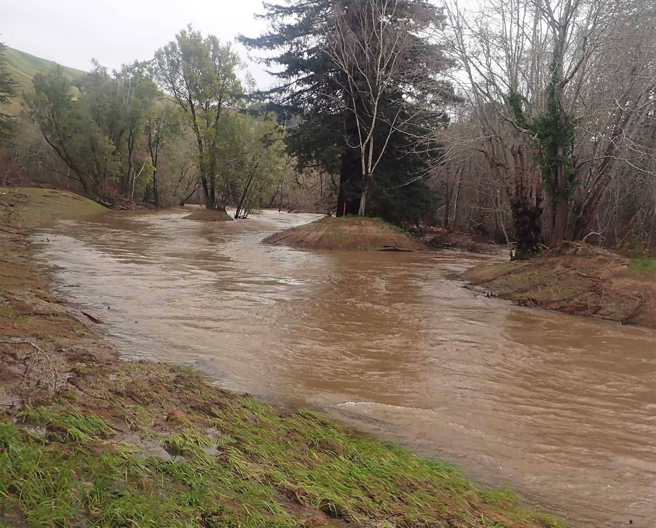
Winter storms bring water flowing to SPAWN’s floodplain project in early February 2019 at about 3,500 cubic feet per second.
The Salmon Protection And Watershed Network’s (SPAWN) most recent restoration project has created a side channel complex in Lagunitas Creek which acts as a nursery habitat for juvenile Coho salmon, steelhead trout, and California freshwater shrimp, all of which are endangered species in California. Lack of adequate winter rearing habitat caused by creek incision, development, and disconnection from the floodplain, have been shown to be limiting factors for stable salmon populations. These new side channels are activated both in the summer and during the winter, reconnecting the main channel with the floodplain and having many positive impacts to the whole ecosystem.
In October, SPAWN completed restoration of seasonal and perennial side channels adjacent to Lagunitas Creek, where several houses of the former town of Tocaloma were taken out and thousands of tons of debris were dug out and removed. The goal of this project is to restore native riparian habitat and regain the wetland-floodplain complex, providing nursery habitat for endangered Coho salmon and steelhead trout, as well as endangered California freshwater shrimp.

The floodplain project during a winter storm at which the creek reached record height at about 2.8 feet. At times, water levels changed by one foot per hour.
Sustained flows in the side channels over the winter and early spring months maintain excellent fish habitat, especially for highly mobile juvenile salmon trying to avoid the high flows of the main channel and forage on insect prey washed into the stream from the surrounding floodplain. Reconnecting the main stem with the floodplain has huge advantages for the whole ecosystem.
First, it activates the food web, providing better quality and diversity of food, where fish gain access to upland, soil-living invertebrates. Second, it reduces flooding and high energy flows because water can dissipate laterally, creating slow-moving water conditions that are preferred by juveniles. Third, the floodplain connection helps to sort the sediment that enters the creek. As water drains into the creek, floodplain topography and mature riparian plants sort fine sand from coarse gravel, holding back the fine sediment and storing it on the floodplain. This allows the riffles and spawning beds in the main channel to be free of fine sediments, with less sand and more stones, the riffles are better oxygenated and more productive. Redds made with coarse sediment such as stones and cobbles will also be less likely to get washed away when there is highly turbulent water, and the eggs are less likely to get smothered by sand and silt particles. The high winter flows seen at the restoration site deposited large plumes of course gravel in the side channels which harbor insect prey and provide fish more habitat to build their redds. Clean gravel with steady pulses of water are beneficial for aquatic insects, such as caddisflies and mayfly nymphs, which are an important food source for Coho salmon and steelhead trout.

Water flows through the floodplain project in early March 2019 at about 200 cubic feet per second.
Increasing the volumes of large woody debris is another important goal of this project. Many mature trees have been left in place to help align the channel, and anchored wood structures help direct water into the side channels, wrack up additional large woody debris, and create scoured pools. Live willow structures planted in the bed of the channel help provide shade, cool water and dynamic flows, help prevent creek incision, as well as provide habitat for insects. These live structures are adaptable and can keep pace with the aggradation or degradation of the channel bed profile without becoming smothered or scoured away. Willow stakes have been planted along the stream banks to provide shade, insect habitat and erosion control. CA freshwater shrimp habitat was also created along sections of the lower bank using live willow stakes and coir wattles that mimic an overhanging bank with live roots of willow providing habitat underneath. Native riparian plants with adventitious roots were planted to create shade and shelter and harbor diatoms, a food source for the shrimp.
SPAWN staff and interns have been monitoring the project since construction and have collected data on how the site has performed and functioned. Data was collected on the maximum daily flow over the past winter season from the USGS stream gauge approximately a mile upstream (Figure 1). Days highlighted in red had a maximum flow over 40 cubic feet per second (cfs), which represents the threshold needed to activate side channels and allow water to flow through them. After February 13th, however, the maximum threshold increased to 100 cfs because large storms brought in huge gravel deposits that filled in the mouth of the side channel. The results of the data show that the seasonal side channel was activated for a total of 75 days from November 2018 through April 2019. The duration of winter flows is important because the longer the water flows through, the more opportunity exists for fish and insects to colonize it and for fish to set up feeding lanes and territories. The greatest duration of flows occurred during February and March when the channel was activated 80% of the time. The longest period of continuous activation was at the end of February/beginning of March when the channel was flowing for 19 consecutive days. The perennial side channel has continued to flow through the winter, spring, and will flow all summer.

Figure 1. Floodplain activation based on maximum daily flows from Nov 2018 – Apr 2019. Days highlighted in red represent flows above the threshold needed for through flow of the side channel, and days in green represent flows below the threshold.
Data was taken before (2016-17) and after (2018-19) the restoration project to monitor the height of the water during winter storms (Figure 2). This was done by installing a staff gauge in the floodplain. During storms the level of the water was recorded using the height it registered on the gauge. The gauge was left in place during construction to get an accurate reading pre- and post-construction. We compared stream height to USGS stream flow data using the date and time of the recording, accurate to the nearest 15 minutes, and found a strong positive correlation for both data sets. As a result of the project, we have seen a reduction in flooding at the staff gauge by at least 1 foot on any of the recorded storms. This is likely due to the fact that by removing over 11,000 cubic yards of dirt and debris, and allowing the floodplain to help absorb the runoff, space was created to handle water flows where water had not previously been able to spread out and sink into the ground. In total, 11,000 cubic yards of debris translates to about 2 million gallons of water that can occupy the space now available on the floodplain.

Figure 2. Discharge vs. Water Surface at the project site during the winter of 2016-17 compared to 2018-19.
Human activities such as dam building and development have changed the landscape over time, causing creek incision that disconnects streams from their historic floodplains. The loss of floodplain connectivity is a loss of critical habitat that supports stable salmon populations. Juvenile salmon spend up to two years in their natal stream where they seek out microhabitats to rest, feed and grow. Side channels are among the most fertile and highly productive microhabitats. This new side channel and floodplain habitat is an example of productive rearing habitat for salmonids with low velocities and dynamic flows in both summer and winter. In addition to providing critical habitat for endangered salmonids and other wildlife, and improving the overall ecosystem function, this project has also helped reduce flooding in the areas adjacent to the restoration site.


